On Friday August 18, 2006 the San Francisco Sheriff's Department "Daily Jail Count" sheet was published, as it is five days a week throughout each year.
The sheet is an informal numeric breakdown of the prisoner population in each of the six (at the time) separate county jails overseen and managed by the Sheriff's Department.
The Daily Jail Count sheet is emailed each weekday morning to management staff, Jail Commanders, and to virtually every other unit in the Department tasked in any way with monitoring jail populations levels, prisoner overcrowding, and a host of related issues.
The August 18th "Count Sheet" showed a total of 2,181 prisoners in the system-- at the following six jails:
• County Jail 1 on the 6th floor of the Bryant Street Hall of Justice;
• County Jail #2 on the 7th floor of the Hall of Justice;
• County Jails #8 and #9 in two separate (but joined) buildings built directly behind the Hall of Justice; and,
• two separate county jails in San Bruno-- County Jail #7 and County Jail #3.
Three days later the Monday August 21st daily count sheet showed 2,259 prisoners, but “County Jail #3” was no longer on the list.
The new jail designation "County Jail 5" appeared, a seemingly innocuous entry, but it signified a major change in San Francisco history and in the history of the San Francisco Sheriff’s Department.
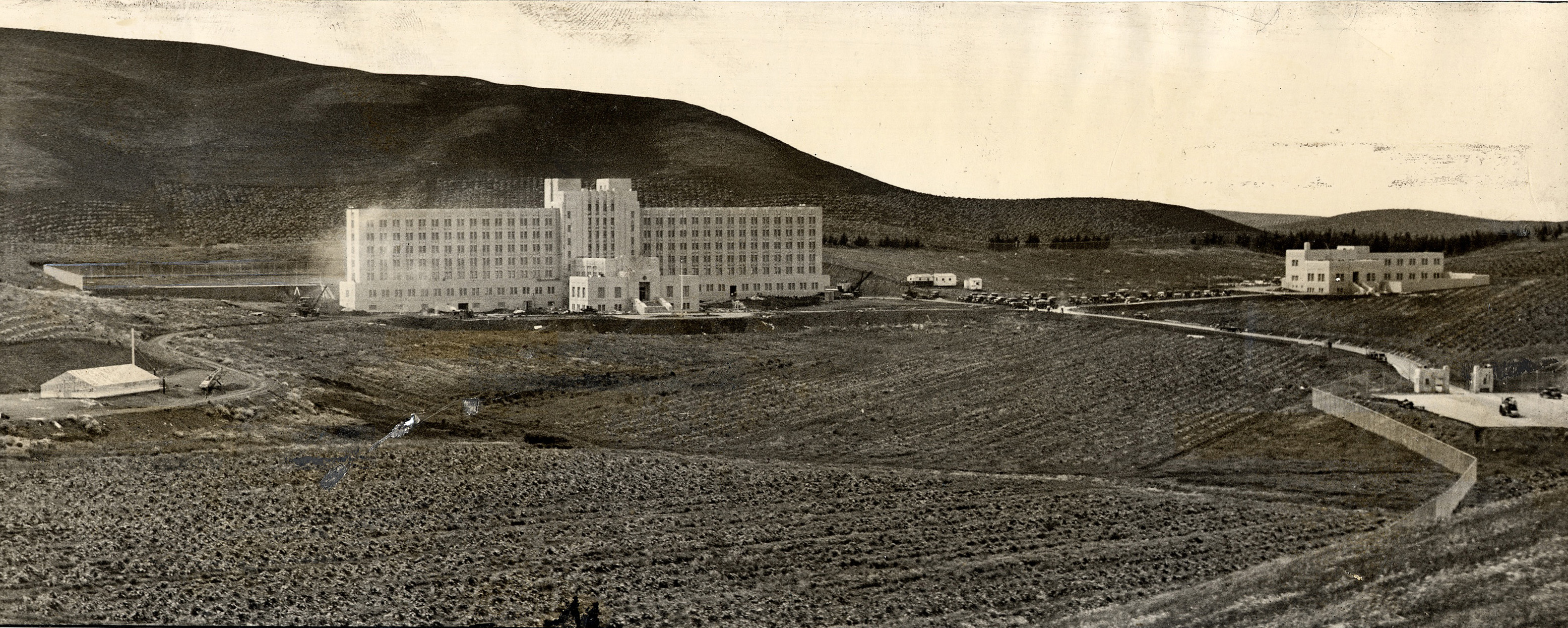
San Francisco County Jail No. 2 in rural Mateo County in 1934. The jail's greenhouse, which supported prisoner farming projects, is on the far left. The main jail building, with administrative offices and six tiers of jail cells, is center. Just behind that building is the main jail's prisoner exercise "yard". The women's jail was located in a separate building on the upper right. The front gate and entrance is seen in the middle right. This photo was taken from Sneath Lane, which still fronts the western boundry of the jail grounds.
After 72 years, County Jail #3 in rural San Mateo County near the city of San Bruno, the oldest working county jail in California, had been shut down.
From 1934 until 2006, the San Francisco County Jail at San Bruno completed the familiar arc that most seven decade old municipal buildings might experience. Built in the early 1930s, the structure was a cutting edge technological wonder and hailed as the most modern jail in the world.
But the San Bruno jail would end its days as a crumbling artifact whose safety and security the local media compared to the legendary Black Hole of Calcutta. During its final twenty years the San Bruno county jail caused the City of San Francisco to be held in contempt of court for continuing to keep it open; the facility generated major lawsuits against the Sheriff’s Department and was frequently in the news because of prisoner escapes and assaults.
And yet, in the 1990s, San Francisco voters twice rejected bond measures to tear the old jail down and replace it with a modern, safe facility.
But maybe the most amazing aspect of the San Bruno jail story is just how San Francisco County was able to build a massive, seven story correctional structure on land located in a neighboring county.
In later years, when two additional jails were built on the same site, people living in the new suburban housing that now surrounds the San Bruno jail grounds also wondered exactly how San Francisco was allowed to continue to construct its jails sixteen miles inside the boundary of San Mateo County.
The fact that the original jail outdated their arrival in the area by over forty years didn’t seem to be a relevant fact.
The very first residents of the rolling hills west of Skyline Boulevard in the shadow of Sweeney Ridge were a sub-group of a Native American people who lived throughout the central and northern California coast for thousands of years.
The Land and the Yelamu Ohlone Indians

But in the early 19th century, this was mainly vast grasslands— part of what was called the northern coastal prairie. Enormous swaths of land that have since been farmed, developed, and inundated with invasive species were once part of a vast ocean of knee-high coastal grasses as far as the eye could see.
Native California oatgrass and purple needle grass are still in evidence along Sweeney Ridge above San Bruno, from whose mountain range you can view the entire width of the San Francisco peninsula, simultaneously viewing the Pacific Ocean and San Francisco Bay.
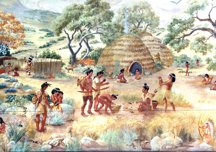
A typical Northern California/Bay Area Ohlone people's village. (San Mateo County Library)
In 1769 Gaspar de Portola became the first Spanish explorer to view San Francisco Bay, from the 1,200 foot summit of Sweeney Ridge. Portola made contact with various Ohlone tribes during his Bay Area explorations, including the Yelamu group who lived in a village called Urebure next to San Bruno Creek.
The Rancho Buri Buri Mexican Land Grant
Under Spanish rule, from 1769 to 1821, land grants were awarded to new settlers throughout Alta California. While these grants allowed settlement and grazing rights, the actual title and ownership of the land was retained by the Spanish crown.
During the subsequent Mexican rule, from 1821 to 1846, Alta California land grants were awarded directly to individuals. And so it was that Governor Jose Castro awarded Rancho Buri Buri (a variant of the Yelamu village “Urebure”) to Jose Antonio Sanchez in 1836.
Rancho Buri Buri was 14,639 acres of lush landscape that ran from today’s south boundary of San Francisco, down south to the middle of present-day Burlingame. It bordered San Francisco Bay on the east and on the west by the hills of Pacifica.
For 10 years, Jose Sanchez leased much of the property as prized grazing land for cattle, horses and other stock to Mission Dolores and the Presidio of San Francisco.
In 1846, the United States declared war on Mexico and when the Treaty of Guadalupe Hidalgo ended the conflict on February 2, 1848, it was announced that all Mexican land grants would be honored. Problems arose when land grant owners were tasked with actually proving they owned the land and the how boundaries were determined.
Eventually many land grant owners had to sell some or all of their property to fund costly court and survey actions and land grant ranchos throughout the new State of California started to vanish.
Over the next twenty-five years the heirs of Jose Antonio Sanchez were forced to sell the Rancho Buri Buri property to a series of owners and partnerships, who then sold large plots of the property to other buyers.
Richard Sneath's Jersey Dairy stretched from what is now El Camino Real (bottom of photo) west to the coast hills of Pacifica, CA. (From the collection of Darold Fredricks, featured in the Daily Journal)
In 1875 Richard Sneath purchased a 1,200 acre plot of land which had been part of the Rancho Buri Buri land grant, planning to build a dairy business. Sneath would soon expand his land holdings in the area to a total of 2,000 acres and construct buildings and create parceled pasture lands for Jersey cows.
The Sneath Dairy was roughly bounded on the on the north by present-day Westborough Boulevard in South San Francisco, on the south by present-day Sneath Lane, on the west by the foothills northwest of Sweeney Ridge, and on the east by El Camino Real.
The vast tracts of open grassland in the northern Peninsula were perfect cattle grazing land and soon other dairies sprung up in the area. Business went well for a time but ultimately increased competition forced the dairies to consolidate, and several eventually sold off their assets.
Richard Sneath’s vast properties became part of the accelerated urban growth up and down the San Francisco Peninsula throughout the 20th century. In 1939, 180 acres of Sneath property was sold to the US government to create the Golden Gate National Cemetery, and soon many housing and commercial developments began to spring up between El Camino Real and Skyline Boulevard.
But the most significant parcel of Richard Sneath’s land would be the 1,500 acres just west of Skyline Boulevard known as “Jersey Dairy #2”.
San Francisco’s Growing Pains Create a Jail Controversy
In 1930 the San Francisco Sheriff’s Department had two jail facilities. County Jail #1, the “felony wing” inside the fifteen year old Hall of Justice at Kearny and Washington Streets had 340 beds/dorms for men and women. The other facility was the Ingleside Jail in the southern part of San Francisco near the border with San Mateo County.
Initially used in 1876 as the House of Correction, the buildings had been expanded in 1892, and the Ingleside Jail was created— 600 beds for housing men and 150 beds in an unattached women’s building.
Not only was Ingleside’s wooden construction deemed a serious potential fire trap, the original structure had been expanded twice, and there had been additional repairs after the 1906 earthquake.
Finn noted several years later that “the present Ingleside building had been condemned time after time as unsanitary and unsafe.” That exact phrase would be used throughout the 1980s and 1990s to describe the Ingleside Jail’s replacement, the San Bruno jail.
Ultimately, the most compelling argument for shutting the facility down was the fact that the Ingleside Jail’s remote location was no longer “remote”.
Over the years, new housing developments had all but completely surrounded the jail grounds as San Francisco was finally expanding to its borders. All of which meant that headlined articles in the Chronicle, Examiner, and Call Bulletin about prisoner escapes and jail drug smuggling had new implications for the families and businesses who had recently located to the Ocean View neighborhood.
By 1924, the residents and business interests in the Ingleside neighborhood were organizing and actively pressing the Board of Supervisors to shut the jail down.
In February 1924, Board of Supervisors member Eugene Schmitz (who was San Francisco’s mayor from 1902 to 1907) introduced a resolution to the Board urging that the Ingleside facility be physically moved to another location. Schmitz noted that the San Jose and Ocean Avenues location could be “sold at a profit by the city for residential purposes.”
When the Board floated a proposal to build an addition to the Ingleside Jail in nearby Balboa Park, the jail issue went from residents expressing their concerns to residents talking about forming an armed force to prevent it.
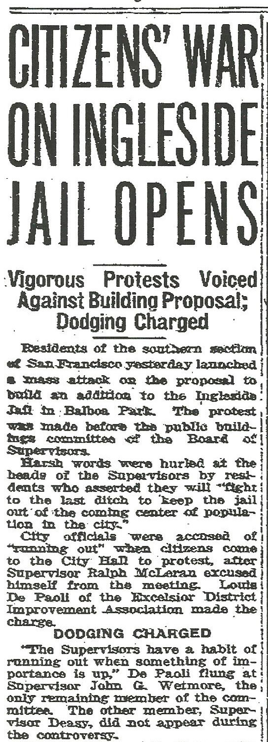
“Citizens’ War On Ingleside Jail Opens” screamed a December 4, 1925 headline in the San Francisco Chronicle.
“Residents of the southern section of San Francisco yesterday launched a mass attack on the proposal to build an addition to the Ingleside Jail in Balboa Park”.
“Fred Steinmann of the Excelsior District Merchants’ Association… predicted that citizens would present an ‘armed force’ if necessary to combat the project.”
An exasperated Sheriff Finn declared the he was “not in favor of Balboa Park for the jail, but we have to have some place. Find me a place to put up a new jail where fifty acres are available.”
The public outrage got so bad that members of the Board of Supervisors were accused in the newspapers “of ‘running out’ [of the building] when citizens come to the City Hall to protest”.
Attorney H. H. Hubbard, representing the incensed residents, suggested a new jail be constructed in Portsmouth Square, opposite the Hall of Justice on Kearny Street. Members of the Board of Supervisors rejected this out of hand.
Hubbard said things were so bad in the jail’s southwest neighborhood that the “moral tone” of the Ingleside community had been “lowered” by the presence of the jail and that the neighborhood children were "playing jail games" as the result of its influence.
The Politics of Expansion versus San Mateo County
By the late 1920s there was a clear mandate for the City and County of San Francisco to build a modern new county jail to replace the Ingleside jail, but no clear consensus on a location for the new facility.
On April 13, 1928, newly elected Sheriff William J. Fitzgerald appeared before the Board of Supervisors’ Finance Committee and requested $464,080 be put in the Sheriff’s 1928-29 budget to physically move the Ingleside Jail to the Bayview district, tucked deep into the southeast corner of the City.
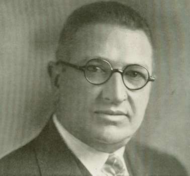
William Fitzgerald was sworn in as Sheriff on January 3, 1928, succeeding political boss Tom Finn. Fitzgerald inherited the problem of replacing the fifty-six year old Ingleside Jail.
The following day, an SF Chronicle article described what happened next. “Hardly had Fitzgerald made his suggestion when the Bay View Promotion Association filed a formal protest against locating the jail in any part of the district.”
A Bayview/Hunters Point location for a new jail was still being studied a year later, but at the same time San Francisco was waiting to hear from California State legislature on an important development in the new jail scenario.
A jail bill had been submitted in Sacramento by San Francisco Assemblyman James Quigley, who represented the 24th District encompassing the outer Mission neighborhoods. That bill would permit the City to construct its new county jail outside the city limits in another county.
A former member of the San Francisco Police Department, Quigley was looking to move up the political food chain and had his eye on the office of San Francisco Sheriff. Assemblyman Quigley was eager to carry the water in Sacramento to solve the City’s jail problem with the added benefit of attaching his name to the future of the San Francisco Sheriff’s Department.
California Governor C.C. Young (1927-1931) greenlighted dozens of major public works projects throughout the State during his single term, including procuring water from the Colorado River and the building of the San Francisco-Oakland Bay Bridge.
First, were several bills that provided clearance for the building of the San Francisco-Oakland Bay Bridge, including making the new bridge part of the State highway system and approving the structure of the revenue bonds needed to fund construction.
Also in front of Governor Young was the “Williamson bill” which eliminated a number of obstacles to the possible consolidation of San Francisco with all or parts of San Mateo County.
There was a growing consensus among officials of both counties that southern California had become California’s biggest population and business magnet and that San Francisco needed to grow if it hoped to remain an influential player in State politics.
And finally, waiting for Young’s signature was the “Quigley bill”, which allowed the board of supervisors in one county to purchase property in another county for use in the construction of a county jail (or other penal institution).
The bill also specified that the board of supervisors in the county in which the county jail is to be constructed must first give their approval.
Although the Quigley legislation did not name San Francisco and San Mateo, it was written specifically for the San Mateo Board of Supervisors to grant San Francisco the right to build their new Ingleside replacement jail in San Mateo County.
Each of the San Francisco bills would be approved over the next month, including the Quigley bill which Governor Young signed on May 25, 1929.
The next order of business was to secure funding necessary to build a new county jail.
On September 23, 1930, the San Francisco Board of Supervisors approved the placement of Bond Measure #38 on the City’s ballot for the November 4, 1930 elections. The measure called for $850,000 in bonds to be sold for the construction of a new county jail at a site yet to be determined.
Bond Measure #38 required a 2/3 vote in favor to win and on election day San Franciscans overwhelmingly passed the new jail bond with a 77% majority-- 104,754 to 31,339.
Those San Francisco voters who followed the politics behind the new jail in the local newspapers likely got the feeling that everything was seamlessly coming together to replace the old Ingleside buildings with a safer, more modern county jail.
A majority of the Board of Supervisors favored new jail construction and Mayor James Rolph, who would resign in January 1931 to become Governor of California, had supported funding a new facility.
San Francisco Sheriff William Fitzgerald was also an enthusiastic supporter, and his influence and political maneuvering was clearly evident in newspaper reports on the new jail process.
But 1931 was an election year in San Francisco.
The upcoming decisions which would determine exactly where the new jail would be built generated serious hardball politics among members of the SF Board of Supervisors, the Sheriff, and a number of influential San Francisco County and San Mateo County policymakers.
In a tough race for a second term as sheriff, Fitzgerald faced two strong and vocal contenders in Assemblyman James Quigley and SF Board of Supervisors member Jack Spaulding, who had been Fitzgerald's undersheriff during his first term. The new jail project quickly became a political football and Fitzgerald found himself fighting a two front war, one for his political survival and one to get the new jail built.
Creating Counties on the Run
In the late 1920s and early 1930s, there were two pivotal issues directly involving San Francisco and San Mateo County.
First was the construction of a coastal highway down the length of the San Mateo County coast, connecting San Francisco and Santa Cruz.
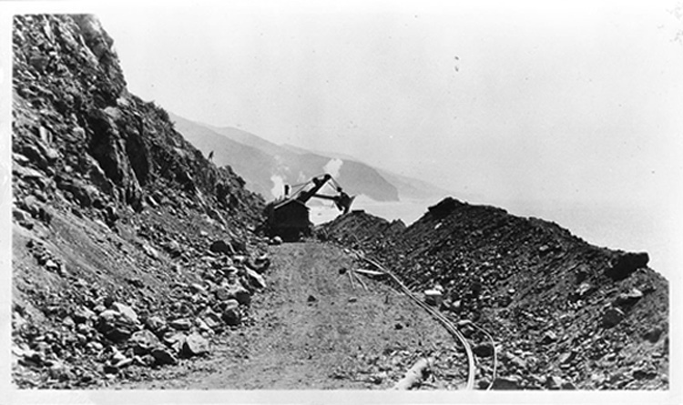
California's new coast highway under construction in Ventura County in the early 1920s. Each coastal county in the state was tasked with partially funding the project as well as lobbying Sacramento for sufficient funds to complete their portion of the new highway. As a result California's coast highway was built in various sections from 1919 to its completion in 1937.
The second issue concerned an organized movement to reunify San Francisco County and San Mateo County.
When California was admitted to the Union in 1850, the State officially created twenty-seven original counties. But between 1851 and 1907 (when Imperial County was the last county formed) thirty-one additional counties were created by carving them out of existing counties.
Alameda County, for example, was created out of parts of Contra Costa and Santa Clara Counties in 1853.
The original San Diego County was massive. It stretched from the Pacific Ocean and went hundreds of miles northeast, taking up over one third of California’s western border with what would become the State of Nevada in 1864. But no original county in the state was bigger than Mariposa County, which was eventually almost completely carved up. In 1850 Mariposa was bigger than the state's current largest county- San Bernadino.
San Francisco County’s original northern boundary was the Golden Gate, and its southern border was at San Francisquito Creek in Palo Alto, at the Santa Cruz County line. Initially, there was no “San Mateo County”.
In 1856 the State legislature created San Mateo County, pushing San Francisco’s southern boundary just over 20 miles north, above the city of Colma. San Francisco then became the only “City and County” in the State and one of the few in the nation.
Apparently not content with that, in 1868 San Mateo County also annexed a huge portion of coastal land from Santa Cruz County. See the California State Association of Counties site for a series of maps detailing the formation of California’s 58 counties.
The Twenty-five Year Journey to Expand San Francisco
A movement sprung up in the late 1920s to reunify San Francisco and San Mateo Counties and a committee that included San Mateo and San Francisco officials was formed to come up with recommendations.
In Southern California the city of Los Angeles was growing exponentially, gobbling up the incorporated and unincorporated cities around it, shifting the State’s geopolitical focus. Shipping, manufacturing, and the blossoming film and entertainment industry were putting Los Angeles on the map.
The fear was that San Francisco, and Northern California in general, were losing political and business influence to Los Angeles and would eventually become marginalized. In 1920, the population of the city of Los Angeles was 576,700-- by 1930 it more than doubled to 1,238,048.
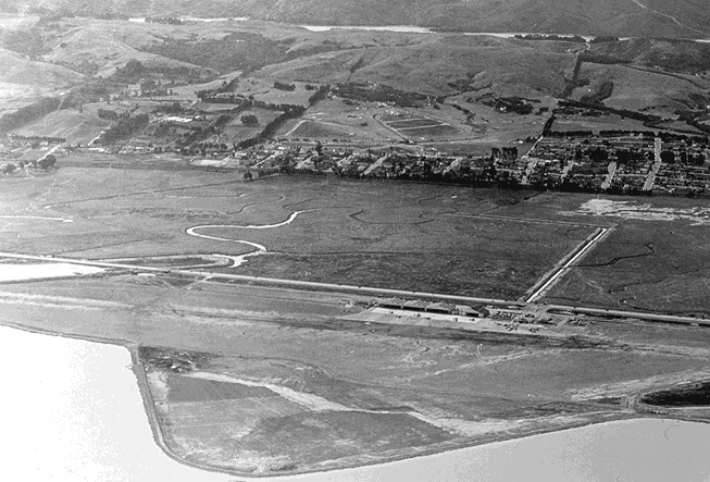
San Francisco's International Airport began as Mills Field Municipal Airport in 1927. That year, San Francisco rented the property from the Mills family for three years to assess whether proper landing strips could be built on its marshy soil. In 1930 the City bought that land, and much more, from the Mills Estate and began to expand its new airport.
There’s little doubt that the San Francisco Board of Supervisors worked to increase the City’s presence in San Mateo County in the late 1920s and early 1930s, and locating their new county jail there could help the push for reunification.
The “San Francisco-San Mateo Consolidation Committee”, formed in 1929, spent three years developing a unification report for the Boards of Supervisors of both counties. When the final report was presented to San Francisco’s Board on January 5, 1932, committee members appointed from both counties were confident that one of two proposals would be eventually adopted.
The first plan was to annex the northern part of San Mateo County to San Francisco, down to the Redwood City border. The alternate plan was total annexation to the Santa Cruz County line, which would essentially re-create San Francisco’s original 1850 boundary lines.
In both proposals, a “borough” form of government would be created, based on the boroughs that made up New York City. On December 21, 1931, the Committee’s counsel, San Mateo attorney C.M. Kirkbride, told the SF Chronicle that there was “agreement on nearly all of the more vital questions”.
It was expected there would need to be various elections in San Francisco and among participating cities in San Mateo County before the project could officially move forward. But it looked like a done deal, and the Committee estimated the final county consolidation target date would be mid-1935.
In the end, San Mateo County elected officials were much more concerned with being marginalized by joining San Francisco County than by a population explosion happening 400 miles away in in LA. South San Francisco City Attorney J. W. Coleberd led the growing opposition saying, “The balance of power [if the two counties were unified] would be in San Francisco”.

San Francisco's mayor from 1931 to 1944, Angelo Rossi was a successful florist when he was picked by the Board of Supervisors to finish the term of Mayor Jim Rolph, who had been elected governor. Rossi won two more terms but lost his third election campaign. He was mayor during the City's infamous general strike of 1934, when two strikers were killed by the police, and was known for his vocal anti-union and rabid anti-communist stances. His support of Italy's fascist dictator Benito Mussolini damaged his public image and likely cost him a fourth term as mayor.
After the initial consolidation proposal stalled for a period of time, San Francisco Mayor Angelo Rossi came up with a much broader vision. In mid-1933, Rossi proposed adoption of a “metropolitan area” government-- a series of boroughs which included all cities within a fifty mile radius of San Francisco.
Included in the new annexation plan were several dozen cities in Marin, Alameda, San Mateo and Santa Clara Counties.
That was an epic overreach which effectively stalled and derailed any expansion plans for San Francisco. Within months Rossi saw the writing on the wall and publically retreated to the original San Mateo-only annexation plan. Unification supporters tried several times to revive the initial scheme to join the two counties, and even conceded to a plan that only included the top third of San Mateo County.
But the momentum was gone.
On August 4, 1947 it was reported that San Francisco Mayor Roger Lapham instructed Board of Supervisors member Dan Gallagher to form a committee to seek annexation of San Mateo County “north of Burlingame”. Five years later Supervisor Gallagher would be appointed San Francisco Sheriff when incumbent Sheriff Daniel Murphy died in office. But this latest consolidation project also went nowhere.
The last gasp may have been in April of 1953, with SF Supervisor Ed Mancuso’s proposal that San Francisco annex the Broadmoor and Westlake Districts of northern San Mateo County. By that time, annexation was no longer considered a serious political initiative.
In 1931, by far the most immediate concern for the San Mateo Board of Supervisors was getting their new coast highway built. The quid pro quo for San Mateo allowing San Francisco increased presence by building their new jail in the county was simple: San Francisco would agree to contribute $55,000 to the highway project and lobby in Sacramento for the additional funds needed to complete the coast highway.
Assurances were immediately given that San Francisco would gladly provide State legislative lobbying support for the San Mateo Board of Supervisors as well as help directly fund San Mateo’s coast highway. And once the City’s voters passed the jail bond measure, the business of choosing a San Mateo County site began.
Location, Location, Location
First, San Francisco City Attorney John J. O’Toole affirmed the right of San Francisco to maintain a county jail outside the limits of the City and County, which gave a green light to the Board of Supervisors to create a specific list of proposed sites.
Although resistance by various City neighborhoods had virtually eliminated any chance of a new San Francisco jail site, there was news that the US Government was about to abandon Fort Funston, along San Francisco’s southwest coast. The Board made inquiries to the Federal Government about the Funston site as a possible jail location, but talks apparently didn’t go very far.
Ultimately the legislative clearance to build in San Mateo County made that solution irresistible. And with talk of reunifying the two counties in the air, choosing a location for the new jail in San Mateo County seemed like a smart political move.
Sheriff William Fitzgerald played a major role throughout the jail location vetting process, and his preferences would ultimately become the deciding factor.
A February 7, 1931 Chronicle article described Fitzgerald as “the busiest man in the City Hall. Every day there is a swarm of real estate agents crowded in the room [his office] awaiting the chance to invite the Sheriff for a ride down the peninsula to look at prospective County Jail sites.”
Fitzgerald publically stated that his number one consideration in the selection process was the availability of water at any prospective site, although the coastal mountains provided many sources of water throughout central and western San Mateo County.
In reality, Fitzgerald had another major consideration on his list: a San Mateo County location close to San Francisco.
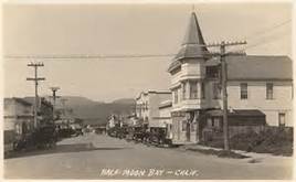
Half Moon Bay in 1927. Newspaper reports in the 1920s and 1930s referenced the little town as "Halfmoon Bay". Originally called "San Benito", Half Moon Bay was actually the first real town in San Mateo County's history because of its growing fishing and agriculture industries.
To get the geographically closer construction location he wanted, Sheriff Fitzgerald would have to finesse San Mateo County officials, as well as deal with a divided San Francisco Board of Supervisors. Certainly the arguments in favor of a closer jail site were compelling.
The 16 mile distance from the Sneath Ranch at Jersey Dairy #2 to San Francisco was half that of several leading sites near Half Moon Bay. The idea of constructing and running a huge county jail facility 29 miles or more from San Francisco, down the desolate coast of San Mateo County, would be an extremely high maintenance commitment.
Prisoner transportation issues would be challenging, as would getting food, water, equipment, and other supplies to the remote location. While the jail was intended to house sentenced prisoners whose cases had been adjudicated, there would still likely be some number of inmates going to and from the courts, located at the Hall of Justice across from Portsmouth Square.
Deputy and other staffing issues would also be a concern— sufficient employee housing and basic amenities, to say nothing of schools and medical needs, were not plentiful that far south along the San Mateo County coast.
The new coast highway was still in the future and the prospect of a daily commute from San Francisco to a location south of Half Moon Bay in the early 1930s would have been daunting.
In all, six San Mateo locations were initially picked as possible jail sites, and all were located along the San Mateo County coast. San Francisco’s Board of Supervisors was not averse to placating San Mateo officials’ by focusing on coast locations, and no doubt the Board also thought that if they had to come up with money to help San Mateo build their new coast highway they might as well get some use out of it.
Not only were all of the six officially proposed county jail locations just north or south of Half Moon Bay, each of the sites was within a mile of the ocean.
• “Site #1” was the Franchesi Ranch, consisting of 200 acres along the Half Moon Bay-Purissima Highway, 6 miles south of the San Francisco County line. The cost was $425 per acre. The location today is obscure, but it would be somewhere north of Pacifica.
The “Half Moon Bay-Purissima Highway” was hardly a “highway”; it was the only extended north-south road along the coastline.
• “Site #2” was property owned by Josephine C. Valencia at Pillar Point on Half Moon Bay Road, 22 miles from the San Francisco County line. This was 240+ acres at $416.00/acre, just under $100,000.
Sites #1 and #2 were dropped early in the process because both were immediately opposed by the San Mateo Board of Supervisors.
• “Site #3” was known as the Cassinelli Ranch, some 420 acres located 1 mile south of Half Moon Bay, 28.7 miles from San Francisco.
The purchase price was $95,000 (about $226.00 per acre). A little over half a mile of the site fronted on the Half Moon Bay-Purissima Highway, and Leon Creek flowed through the NE boundary of the property.
Leon Creek still flows down the coastal hills and is now called Leon Arroyo.
• “Site #4” was called the Butts Ranch located near for former site of the town of Purissima, 3.7 miles south of Half Moon Bay. This was a 283 acre plot at a cost of $450/acre, and was located 32.4 miles south of the San Francisco city limits.
Site #4 was eventually opposed by the Henry Cowell Lime and Cement Company, which owned one tract of property to the north of the Butts Ranch and one to the south. Cowell did not relish having a county jail split their two business properties.
• “Site #5” was the Balanesi Ranch, a total of 220 acres (at $220 per acre) located west of the Half Moon Bay-Purissima Highway, 4 miles south of Half Moon Bay.
• “Site #9” (no mention of any other numbered sites was found) was the Driver Ranch in San Gregorio, the farthest location from San Francisco that was considered. It was fully 40.6 miles from the City on 311 acres, at a cost of $77,750.
With bond money in hand and a handshake deal worked out with San Mateo County regarding their new highway along the coast, the SF Board wasted little time on making a decision.
The Political Needs of the Moment Create History
On May 9, 1931 members of the SF Board toured the various sites, as did Sheriff Fitzgerald, and the six proposed county jail locations were initially introduced at the May 11, 1931 Board meeting.
At their May 25, 1931 meeting, several Board members requested a vote to formally ask approval of the San Mateo Board of Supervisors for the City to purchase the Cassinelli Ranch (Site #3).
The matter was put over until the June 1st Board meeting and passed over yet again on that date because an expected report on another location was due at any time.
The Sneath Ranch’s “Jersey Dairy #2” acreage west of Skyline Boulevard had not made the original location cut, but it was now in play.
At the June 8, 1931 Board meeting a second formal resolution was introduced to ask San Mateo County to approve the purchase of the Cassinelli Ranch site. The Cassinelli location had serious support on the Board and those members wanted to get the deal done. But a decision was deferred for a third time.
Then on June 22, 1931 a third resolution was presented at the weekly Board meeting to purchase the Cassinelli location and two things happened.
First the Cassinelli matter was put off again, for two weeks, in order to get a price on the Sneath Ranch property. Then, seemingly out of nowhere, a vote was taken on purchasing the Sneath Ranch site, and in a close vote the Board voted 9 “yes” and 8 “no”, pending information on the final selling price. Sheriff Fitzgerald's lobbying behind the scenes had apparently paid off.
The following week, on June 29th, the San Francisco Board of Supervisors sent a formal resolution to San Mateo County for consent to build the new San Francisco County Jail at Sneath Ranch.
At this point Fitzgerald's first choice for a jail site appeared to be locked in. Until San Mateo pulled the plug on the entire project.
On August 3, 1931 the San Mateo Board of Supervisors voted 4-1 denying permission for San Francisco to build its new jail at the Sneath Ranch site. A surprised Mayor Angelo Rossi and SF City Attorney John J. O'Toole had attended the county's Board meeting expecting prefunctory approval of the jail project. They listened as the Board stated that the City promised San Mateo County "to contribute $100,000 toward the construction of a new shore line bloulevard between San Francisco and Santa Cruz.... and thus far had given but $35,000".
To up the ante, the Board also mentioned that San Francisco should provide $13,000 to help construct the Junipero Serra Boulevard extension behind the cemeteries in the city of Colma, north of San Bruno.
A flustered Mayor Rossi said the City was doing its best to get the coast highway money to San Mateo. Seeing a political opportunity, SF Board of Supervisors member (and candidate for Sheriff) Jack Spaulding used the delay to attack Fitzgerald's Sneath Ranch site choice and urged that the entire jail site selection process start over.
It took six months before San Francisco officials came through with solid commitments to fund the coast highway. Finally on February 1, 1932 the San Mateo Board of Supervisors voted 4-1 to approve a resolution granting permission for San Francisco to construct their new county jail on the Sneath Ranch property.
On April 4, 1932, members of the San Francisco Board of Supervisors, Sheriff William Fitzgerald, and other City officials joined Mayor Angelo Rossi in his office, Room 200 of City Hall, for a short ceremony. A purchase order from the City and County of San Francisco in the amount of $47,500 was approved to be paid to the Jersey Farm Company for 242 acres of grassland west of Skyline Boulevard at the base of the coastal mountains.
And the final location of San Francisco’s new San Bruno county jail was signed, sealed, and about to be delivered.
------------------------------------------------------------------
References/sources:
SF Bay Area National Parks Science/Learning site; CA State Association of Counties site; "California Ranch Under Three Flags: A History of Rancho Buri Buri in San Mateo County", Frank M. Stanger - California Historical Society Quarterly, Sept 1938; The Daily Journal - a series of San Mateo County history essays by the late Darold Fredricks of the San Mateo Co. Historical Association; San Francisco Main Library - "SF Board of Supervisors Journal of Proceedings 1906-1933" collection; SF Main Library - "NewsBank" San Francisco Chronicle archives; SF Main Library - SF Examiner and SF News Call-Bulletin archives.